Some of the Best Mountain Riding Anywhere in the U.S.
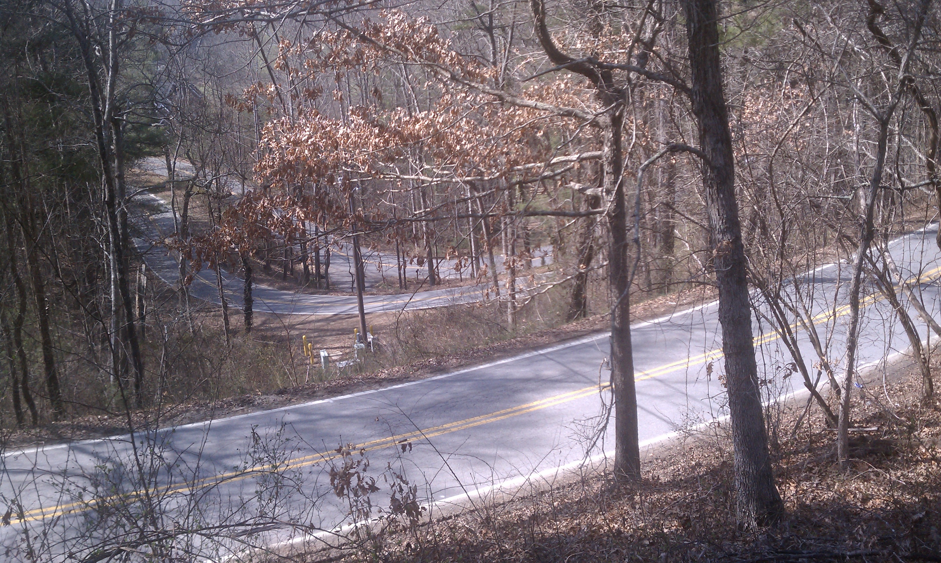
The switchbacks never seem to end on Elk Mountain Scenic Byway, only 3 miles from town
During the 1990s heyday of the Tour DuPont, Asheville was a required visit for the race – which used many of its resident roads and climbs. Despite being a small city, quiet rural roads can be reached from downtown in just a few minutes. Elk Mountain Byway offers a great MTMS Day 2 KOM challenge and starts only 3 miles from downtown. The Blue Ridge Parkway delivers unsurpassed riding, and the city is situated in the valley between Craggy Gardens and Mount Pisgah on the BRP. Northwest of the city are the challenging, rolling hills west of the French Broad river – very popular with local cycling clubs. There is a strong cycling community in Asheville, and the city itself is laced with bike lanes and bicycle shops. Because of its location in a mountain valley, even a ride that the locals consider “flat” or “easy”, is likely to feel hilly and challenging to those from flatter climates. Bring your climbing gearing!!
The 2016 routes will be similar to 2015 in difficulty and character – if on different roads. The organizers will have maps for attendees interested in doing gravel rides in the area, which are excellent. Ride in both the North Mills River area and the Bent Creek Recreation Area, if you like. Ask David Southerland for the hard copies of the gravel ride maps by using the Contact feature at the bottom of the page.
Wednesday, 6:15 PM: Asheville Welcome Ride (2016)
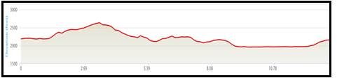
Distance: 14 miles Elevation Gain: 900 feet Character: Hills, flats
Our warm-up ride on Wednesday evening will be an orientation loop around the city of Asheville. Highlights will include a 2 mile climb with a shallow grade up above the Grove Park Inn, a long stretch along the French Broad River, and a finishing climb through the River Arts District. Expect three climbs, a couple of screaming downhills, and long flat section on the river. We should finish with just enough time for you to clean up, get a quick bite, then head out to the MTMS Welcome Gathering (just a few blocks from the hotel).
Click to open a printable PDF map of Wednesday’s Welcome Ride: 2016 Welcome (14)
Click here to go to a GPX file for this Route on Map My Ride.
Thursday, 10 AM: Assault on NC 151 (2016)
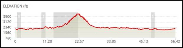
Character: One long, very difficult climb, rolling hills in the country, and a fast, technical downhill
Distances: A Group: 56 miles (with a long climb up NC 151)
B Group: 39 miles (this option will not go up NC 151)
C Group: Same route as B Group, but there are places to cut it shorter
Due to a difference of opinion with the NPS, we have changed Thursday’s route. Our reward is that the A ride today will climb what may be the hardest climb in the greater Asheville area: NC 151 (Pisgah Highway). Both the A and B routes will follow the same roads to the base of 151, but the B riders will go right and continue on the mapped route. The A riders will turn left and assault a 5.3 mile climb at a 6.1% grade. The climb tops out at the Blue Ridge Parkway, where we will do a 180 turn and head right back down. Its a fast, technical downhill that is potentially dangerous. BE CAREFUL!! The A ride will then follow the route of the B ride back to downtown, then do a final inside out loop that will finish on the climb of Broadway and Lexington. We should be hungry by then, and there is an (optional) but wonderful lunch stop scheduled at the Creperie Bouchan at 68 Lexington. Roll your bike right into the courtyard for complete security and a great crepe.
There is no “C” ride today. Follow the route of the A&B rides and if you need to there are two places to cut the ride shorter.
Click for a PDF map of the A/B Rides for the Assault on 151: click here
A Option GPX file at MapMyRide: click here
B Option GPX file at MapMyRide: click here
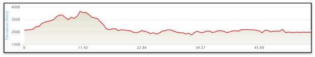
Friday, 10 AM: The Bear Creek Bakery Ride (2016)
Character: Rolling Hills, some tough/short climbs, long section along French Broad river
Distances: A: 50 miles 3,200′ of climbing
B: 35 miles 2,600′ of climbing
C: 38 miles 1,900′ of climbing
This route is one of the true classic Asheville rides (known locally as The Bakery Ride) – and although surprisingly difficult, it will provide a little respite between the very difficult rides on Thursday and Saturday. We will head northwest of town and tackle the rolling hills of Bear Creek Road on our way north to the tiny town of Marshall. B option folks will turn off well before Marshall, but will still get a strong flavor of the character of the longer route. The A route will make the required stop at the Zuma Bakery in Marshall, before heading back to town. Both the A and B options will follow NC 251 (River Road) along the French Broad all the way back to town.
The C Route will do a mostly out and back ride along the French Broad River, finishing on the moderate climb up Broadway back to town. It does have an optional 2.5 mile climb up Ivy Hill Road that averages 4% – riders beware.
Those riders who have the energy will gather at Asheville Pizza and Brewing for an immediate post-ride slice and pint. At the corner of Hilliard and Coxe, at the very end of the ride route.
Click for a PDF map of Friday’s A/B rides: Bear Creek_50_35
Click for a PDF map of the C Ride Route: 2016 Friday C Option
A Ride: 50 Mile GPX file at MapMyRide: click here
B Ride: 35 Mile GPX file at MapMyRide: click here
C Route: GPX file of the French Broad River Tour: click here
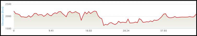
Saturday, 10 AM: The Sunset Blue Ridge Tour (2016)
Character: 3 multi-mile climbs, great views, screaming downhills, ridge riding on Sunset
Distances: A Ride: 56 miles 4,100′ of climbing
B Ride: 28 miles, 2,100′ of climbing
C Option: a tour of the Bear Creek roads
This ride will tackle a new route high above the Grove Park Inn winding our way along the ridge riding of Sunset and Old Toll Roads, before hitting a 5 mile climb, a short downhill, and another 2.5 mile climb. We will descend Elk Mountain Scenic Byway – be careful. We will work our way over to the French Broad River, explore some new roads in the Flat Creek area, then cross the river to play in the Bear Creek basin. The B option will head south back to town at the river.
The C Option will head back out to the great roads northwest of the city, in the area locals know as Bear Creek. This route will do a different combination of the roads that were so much fun on Friday. Rolling hills, with some short tough climbs to keep this interesting. But no long extended climbs. 44 miles, but there are some obvious places to create shortcuts if you wish (see map below).
We will gather at The Wedge Brewery (37 Paynes Way) in the River Arts District after the ride to celebrate 3 days of tough rides. Great outdoor space on the river, and the consensus winner for Best IPA in Asheville for the last decade. Its the classic post-ride move in this town. Enter from Lyman Street at the RR tracks.
Click for a PDF map of the Blue Ridge Sunset Tour: 2016 Saturday A and B_57 and 28v2
Click for a printable PDF map of Saturday’s C Ride: 2016 Saturday C Ride
A Ride: Blue Ridge Sunset (57) GPX file at MapMyRide: click here
B Ride: Blue Ridge Sunset (28) GPX file at MapMyRide: click here
C Ride: 44 mile GPX file at MapMyRide: click here

Pingback: On Your Own Today | Major Taylor Mountains Summit - 2016
Pingback: Route Planning Help, Beer City Bikes and SRAM | Major Taylor Mountains Summit - 2016
Pingback: MTMS Housekeeping (READ THIS!!) | Major Taylor Mountains Summit - 2016
Who is bring their ‘better half’ to the MTMS?
LikeLike
Pingback: Bang On My Drum All Day… | Major Taylor Mountains Summit - 2016
Pingback: Major Taylor Mountains Summit - 2016
Pingback: Kit Store to stay open to 3/14 | Major Taylor Mountains Summit - 2016
Pingback: One More Day to Get the 2016 Kit | Major Taylor Mountains Summit - 2016
Pingback: Time to Get Ready!! | Major Taylor Mountains Summit - 2016
Pingback: Final Reminders!! | Major Taylor Mountains Summit - 2015
Pingback: Maps, GPX files, Wednesday’s Ride and More! | Major Taylor Mountains Summit - 2015
What gearing ratios are some of you guys running for this ride. I live in DE so we don’t have any real hills here. Just looking to get an idea. Thanks
LikeLike
I run a 36×28 as my easiest climbing gear. You should be good with your 34×28. Not sure how far you are from Baltimore but we are doing hill training rides each Saturday leading up to the Summit. Let me know if you’re interested and I’ll send the schedule. Hope this helps.
LikeLike
After Thursday’s ride he Baltimore Metro Wheelers will host a get together at a local establishment. This will be a great opportunity to hang out after the ride for lite eats, drink, a bit of bragging about your day in the saddle and socializing! Make sure you stop by! Details are being finalized.
LikeLike
What gearing ratios are some of you guys running for this ride. I live in DE so we don’t have any real hills here. Just looking to get an idea. Thanks
LikeLike
When I was younger I could ride these mountains with a 39×25 granny gear…but that was a long time ago. Unless you are super strong, a compact crankset is the way to go. If you live somewhere flat and can’t swap out your 52/39 setup, get a 27 or 28 tooth cassette. Best wishes.
LikeLike
Thanks Maccattackatl. I am running a compact crankset (34/50 x 11/28) now. So hopefully that (and dropping a few ponds) will suffice.
LikeLike
Pingback: The Summit Kit: Order deadline is February 2nd!! Other stuff, too. | Major Taylor Mountains Summit - 2015
Pingback: Pay Buttons, Elk Mountain, and an Early Girl | Major Taylor Mountains Summit - 2015
Elk Mountain has just been listed as a top 5 bicycle route by Bicycling Magazine. You would have to travel to California or Hawaii to beat out Asheville ! Pittsburgh Major Taylor will be in the ” House” in Asheville!
LikeLike
Pingback: One World, Gravel Riding, and Lodging | Major Taylor Mountains Summit - 2015
The routes look great Dave. Are they going to be posted on Ride With GPS or Garmin Connect?
LikeLike
John,
Yes, once the routes are finalized we will post the link to GPS data through Map My Ride. I have been told by Garmin users that they can download the info from there and it works fine, although I am not a GPS user myself. I’m guessing we will put something up in March. Thanks for asking.
David
LikeLike
I’ve been to a few rides this fall where PDFs were issued via Ride with GPS. The areas were remote (bad cell service) and so having the PDFs available on one’s smart phone was handy – for those without GPS…
LikeLike